Stegerveld
 From Wikipedia the free encyclopedia
Stegerveld | |
|---|---|
Hamlet | |
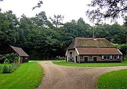
 Farm in Stegerveld | |
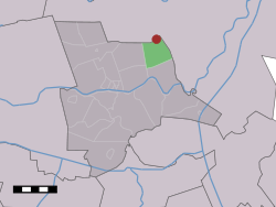
 The village (dark red) and the statistical district (light green) of Stegerveld in the municipality of Ommen. | |
| Coordinates: 52°34′19″N 6°29′55″E / 52.57194°N 6.49861°E | |
| Country | Netherlands |
| Province | Overijssel |
| Municipality | Ommen |
| Area | |
| • Total | 8.49 km2 (3.28 sq mi) |
| Elevation | 7 m (23 ft) |
| Population (2021)[1] | |
| • Total | 360 |
| • Density | 42/km2 (110/sq mi) |
| Time zone | UTC+1 (CET) |
| • Summer (DST) | UTC+2 (CEST) |
| Postal code | 7737[1] |
| Dialing code | 0529 |
Stegerveld is a hamlet in the Dutch province of Overijssel. It is a part of the municipality of Ommen, and lies about 17 km south of Hoogeveen. A part of the hamlet is located in Hardenberg.[3]
It was first mentioned in 1867 as Stegeren Veld, and means field near Stegeren.[4] The postal authorities have placed it under Stegeren.[5] The Ministry of Defence used to have a munition depot in the hamlet. The end of the Cold War, and complaints of farmers who were in the safety zone, have resulted in closing of the depot in 2005. One of the bunkers was home to bats, and has remained.[3]
References
[edit]- ^ a b c "Kerncijfers wijken en buurten 2021". Central Bureau of Statistics. Retrieved 16 March 2022.
- ^ "Postcodetool for 7737PA". Actueel Hoogtebestand Nederland (in Dutch). Het Waterschapshuis. Retrieved 15 March 2022.
- ^ a b "Stegerveld". Plaatsengids (in Dutch). Retrieved 16 March 2022.
- ^ "Stegerveld". Etymologiebank (in Dutch). Retrieved 16 March 2022.
- ^ "Postcode 7737 in Stegeren". Plaatsengids (in Dutch). Retrieved 16 March 2022.

