Vall d'Albaida
 From Wikipedia the free encyclopedia
Vall d'Albaida | |
|---|---|
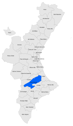
 Location of Vall d'Albaida in the Valencian Community | |
| Coordinates: 38°50′30.64″N 0°32′52.59″W / 38.8418444°N 0.5479417°W | |
| Country | |
| Autonomous community | |
| Province | |
| Capital and largest city | |
| Municipalities | 34 municipalities
|
| Area | |
| • Total | 722.22 km2 (278.85 sq mi) |
| Population (2006) | |
| • Total | 89,798 |
| • Density | 120/km2 (320/sq mi) |
| Time zone | UTC+1 (CET) |
| • Summer (DST) | UTC+2 (CEST) |
Vall d'Albaida (Valencian: [ˈvaʎ dalˈbajða]; Spanish: Valle de Albaida [ˈvaʎe ðe alˈbajða]) is a comarca in the province of Valencia, Valencian Community, Spain.
Etymology
[edit]The name of the comarca is derived from the Hispano-Arabic word albáyḍa, which in turn is derived from the classical Arabic البيضاء (al-bayḍāʾ, "The white one" – reference to the white chalk land of the comarca), from which the yellow flowering plant native to the comarca gets its common name Anthyllis cystoides.[1][circular reference]
History
[edit]Reconquered by the Aragonese king James I of Aragon in the first half of the 13th century it was heavily populated by Muslims until the Expulsion of the Moriscos from the Kingdom of Valencia in 1609.[2]
Geography
[edit]Lying approximately 70 km south of the city of Valencia [citation needed] and covering an area of some 722 square kilometers, Vall d'Albaida borders on the north with the comarca of Costera, to the east with Safor, to the south with Comtat and Alcoià, and to the west with Alto Vinalopó, the latter three of which belong to the province of Alicante.
The Albaida River runs through the comarca from south to north.
Climate
[edit]The area enjoys a typically Mediterranean climate, characterised by hot summers and relatively cold winters, with an average of two snowfalls per year.
Municipalities
[edit]
The Vall d'Albaida comarca is composed of 34 municipalities.
| Municipality | Town/Village | Area | Density |
|---|---|---|---|
| Ontinyent | 36,395 | 125.43 | 290.00 |
| L'Olleria | 8,800 | 32.20 | 251.73 |
| Albaida | 6,269 | 35.40 | 177.09 |
| Benigànim | 6,700 | 33.40 | 184.13 |
| Aielo de Malferit | 4,743 | 27.10 | 167.23 |
| Bocairent | 4,444 | 97.00 | 45.81 |
| Llutxent | 2,571 | 40.10 | 64.11 |
| La Pobla del Duc | 2,561 | 18.90 | 135.50 |
| Quatretonda | 2,513 | 43.20 | 58.17 |
| Castelló de Rugat | 2,391 | 19.10 | 125.18 |
| Atzeneta d'Albaida | 1,364 | 16.20 | 145.92 |
| Montaverner | 1,833 | 7.40 | 247.70 |
| Alfarrasí | 1,297 | 6.40 | 202.65 |
| Agullent | 2,435 | 6.10 | 210.65 |
| Fontanars dels Alforins | 1,014 | 74.70 | 13.57 |
| Bèlgida | 701 | 17.30 | 40.52 |
| Montitxelvo | 626 | 8.20 | 76.34 |
| Benicolet | 577 | 11.30 | 51.06 |
| El Palomar | 555 | 7.80 | 71.15 |
| Otos | 520 | 11.10 | 46.84 |
| Salem | 482 | 8.60 | 56.04 |
| Guadasséquies | 430 | 3.30 | 130.30 |
| El Ràfol de Salem | 421 | 4.30 | 97.90 |
| Bellús | 387 | 9.50 | 40.73 |
| Benissoda | 361 | 4.00 | 90.00 |
| Terrateig | 343 | 6.30 | 54.44 |
| Beniatjar | 260 | 11.40 | 22.80 |
| Bufali | 203 | 3.20 | 63.43 |
| Benissuera | 199 | 1.90 | 104.73 |
| Aielo de Rugat | 197 | 7.80 | 25.25 |
| Pinet | 190 | 11.90 | 15.96 |
| Rugat | 174 | 3.10 | 56.12 |
| Carrícola | 94 | 4.60 | 20.43 |
| Sempere | 38 | 3.80 | 10.00 |
Culture
[edit]Route of the Monasteries of Valencia
[edit]
The Route of the Monasteries of Valencia (GR-236) is a monumental and cultural route that connects five monasteries located in the south of the Province of Valencia.
Of the four different itineraries available, three (by foot, by Mountain bike and on horseback) cross various comarques within Vall d'Albaida, following signposted riding trails, mountain trails, old roads and railroad tracks, and include the Monastery of the Corpus Christi and Xio Castle, both in the municipality of Llutxent.
By foot, the route takes approximately 3–4 days.
The Route was inaugurated in 2008.[3][4]
See also
[edit]References
[edit]- ^ Arabic language influence on the Spanish language
- ^ Haliczer, Stephen. Inquisition and Society in the Kingdom of Valencia, 1478-1834. Berkeley: University of California Press, 1990, 244-272.
- ^ Source: El Mundo (Spain). The route of the Monasteries is inaugurated.
- ^ Source: Las Provincias. The route of the Monasteries: El Pas del Pobre.
- http://palomatorrijos.blogspot.com/2009/12/los-marqueses-de-albaida-pleito-por-el.html
- http://palomatorrijos.blogspot.com/2009/12/los-marqueses-de-albaida-valencia.html
- Amelias GOMEZ MARTINEZ: "Propiedad señorial en el marquesado de Albaida perspectivas socieconómicas del señorío en la segunda mitad del s. XVIII". Published 1988 by Excmo. Ayuntamiento de Albaida in [Albaida] . 1988. 288 pages. Library of Congress HD779.A375 G66. ISBN 84-505-8276-8
External links
[edit]- Comparsa Saudites d'Ontinyent (in English) (en valencià) (en español)
- La Vall d’Albaida (in Valencian and Spanish)
- Mancomunitat de Municipis de la Vall d'Albaida (in Valencian and Spanish)