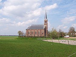
Warstiens
 From Wikipedia the free encyclopedia
Warstiens | |
|---|---|
Village | |
 Warstiens church | |
 Location in the former Boarnsterhim municipality | |
| Coordinates: 53°10′N 5°52′E / 53.167°N 5.867°E | |
| Country | |
| Province | |
| Municipality | |
| Area | |
| • Total | 2.71 km2 (1.05 sq mi) |
| Elevation | 0.1 m (0.3 ft) |
| Population (2021)[1] | |
| • Total | 30 |
| • Density | 11/km2 (29/sq mi) |
| Postal code | 9004[1] |
| Dialing code | 058 |
Warstiens is a small village in Leeuwarden municipality in the province of Friesland, the Netherlands. It had a population of around 35 in January 2017.[3]
History
[edit]The village was first mentioned in 1477 as Wer-steens, and means "parcel of land of Steene (person)".[4] In 1840, Warstiens was home to 27 people. In 1882, a new Dutch Reformed church was constructed in the village. The bell from 1252 of the old church is nowadays on display at the Rijksmuseum in Amsterdam. The church is used for service twice a month.[5]
Before 2014, Warstiens was part of Boarnsterhim municipality and before 1984 it belonged to Idaarderadeel.[5]
Gallery
[edit]- Village centre
- Bench Le lit des coquillages (The seashell bed)
- Canal view
- The harbour of Warstiens
References
[edit]- ^ a b c "Kerncijfers wijken en buurten 2021". Central Bureau of Statistics. Retrieved 31 March 2022.
- ^ "Postcodetool for 9004XM". Actueel Hoogtebestand Nederland (in Dutch). Het Waterschapshuis. Retrieved 31 March 2022.
- ^ Kerncijfers wijken en buurten 2017 - CBS Statline
- ^ "Warstiens - (geografische naam)". Etymologiebank (in Dutch). Retrieved 31 March 2022.
- ^ a b "Warstiens". Plaatsengids (in Dutch). Retrieved 31 March 2022.
External links
[edit] Media related to Warstiens at Wikimedia Commons


