Watermelon Peak
 From Wikipedia the free encyclopedia
| Watermelon Peak | |
|---|---|
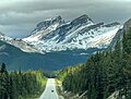
 Watermelon Peak seen from Molar Pass with summit to right of centre and outlier S2 to left | |
| Highest point | |
| Elevation | 3,095 m (10,154 ft)[1] |
| Prominence | 674 m (2,211 ft)[2] |
| Parent peak | Deluc Peak (3182 m)[2] |
| Listing | Mountains of Alberta |
| Coordinates | 51°42′56″N 116°20′35″W / 51.71556°N 116.34306°W[2] |
| Geography | |
 Watermelon Peak Location of Watermelon Peak in Alberta  Watermelon Peak Watermelon Peak (Canada) | |
| Country | Canada |
| Province | Alberta |
| Protected area | Banff National Park |
| Parent range | Canadian Rockies |
| Topo map | NTS 82N9 Hector Lake |
| Geology | |
| Age of rock | Cambrian |
| Climbing | |
| First ascent | 1966 D. Michael, W.V.G. Matthews, W.L. Putnam, M. Stearns, L.R. Wallace[3] |
| Easiest route | Scrambling YDS 3[4] |
Watermelon Peak is a 3,095-metre (10,154-foot) summit located in Banff National Park, in the Canadian Rockies of Alberta, Canada. Its nearest higher peak is Deluc Peak, 13.5 km (8.4 mi) to the east.[2]
History[edit]
Watermelon Peak was named in 1966 by William L. Putnam, member of the first ascent party, which carried a four-kilogram watermelon to the summit, and consumed it there.[5] The July 1966 first ascent party included David Michael, W.V.G. Matthews, William L. Putnam, M. Stearns, and L.R. Wallace.[3] However, the name is not officially recognized by the Geographical Names Board of Canada.[Notes 1]
Geology[edit]
Like other mountains in Banff Park, Watermelon Peak is composed of sedimentary rock laid down during the Precambrian to Jurassic periods.[6] Formed in shallow seas, this sedimentary rock was pushed east and over the top of younger rock during the Laramide orogeny.[7]
Climate[edit]
Based on the Köppen climate classification, Watermelon Peak is located in a subarctic climate zone with cold, snowy winters, and mild summers.[8] Winter temperatures can drop below −20 °C with wind-chill factors below −30 °C. Precipitation runoff from Watermelon Peak drains into the Bow River and Siffleur River which are both tributaries of the Saskatchewan River.
See also[edit]
Gallery[edit]
-
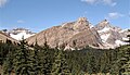
 Watermelon Peak's southern outlier, S2 (2929 m), seen from Icefields Parkway
 -
 Southeast aspect of Watermelon S2 (right) and Dolomite Peak (left).


References[edit]
- ^ "Topographic map of Watermelon Peak". opentopomap.org. Retrieved 2022-02-26.
- ^ a b c d "Watermelon Peak". Bivouac.com. Retrieved 2019-01-10.
- ^ a b "Watermelon Peak". cdnrockiesdatabases.ca. Retrieved 2019-09-08.
- ^ "Watermelon Peak". explor8ion.com. Retrieved 2019-09-08.
- ^ Boles, Glen W.; Putnam, William Lowell; Laurilla, Roger W. Canadian Mountain Place Names: The Rockies and Columbia Mountains. Rocky Mountain Books. pp. 265-266. ISBN 9781894765794.
- ^ Belyea, Helen R. (1960). The Story of the Mountains in Banff National Park (PDF). parkscanadahistory.com (Report). Ottawa: Geological Survey of Canada. Archived (PDF) from the original on 2015-10-02. Retrieved 2019-09-13.
- ^ Gadd, Ben (2008). Geology of the Rocky Mountains and Columbias.
- ^ Peel, M. C.; Finlayson, B. L.; McMahon, T. A. (2007). "Updated world map of the Köppen−Geiger climate classification". Hydrol. Earth Syst. Sci. 11: 1633–1644. ISSN 1027-5606.
- Notes
- ^ The peak is not listed in the Canadian Geographical Names Database.
External links[edit]
- Parks Canada web site: Banff National Park
- Climbing Watermelon Peak: Golden Scrambles
Places adjacent to Watermelon Peak | ||||||||||||||||
|---|---|---|---|---|---|---|---|---|---|---|---|---|---|---|---|---|
| ||||||||||||||||