Yōrō Falls
 From Wikipedia the free encyclopedia
This article needs additional citations for verification. (June 2010) |
Yōrō Falls (養老の滝, Yōrō no Taki) is a waterfall in Yōrō Park located in the town of Yōrō, Yōrō District, Gifu, Japan.

Summary[edit]
The waterfall is 32 meters high and 4 meters wide. It was chosen as one of Japan’s Top 100 Waterfalls. The water from the falls is praised for its high quality, and is mentioned in a legend that tells the story of a dedicated son who offered the water, which tasted like sake to his ailing father who, upon drinking it, was revived.[1] The Empress Genshō, who visited this area, renamed the period of her reign "Yōrō" saying, "Rei Springs art beautiful springs. And so doth nourish the old. Perhaps it be the spirit of the waters. I do [hereby] give amnesty under heaven, and fix the third year of the Reiki (era) anew to year 1 of the Yōrō (era)."
Yōrō Park extends from Yōrō Falls to the Nanno Sekigahara Line, a prefectural road that runs along the foot of the mountain. From the park's parking lot, one must climb a steep hillside road for 700 to 800 meters, but from about midway between the parking lot and the falls, there is a lift running. By taking this lift, one may reach the falls with comparative ease. Also, there is another parking lot nearer the falls. The carbonated beverages like Ramune and cider, which are made using the water, are also popular.
The cider that is made with the local water was once called "Yōrō Cider" and was produced in the town. In recent years, the production of this beverage has been taken over by a different company, and the product renamed "Yōrō Sanroku Cider."
Geography[edit]
The waterfall is in the upstream part of the Taki Valley, which joins in Tsuta River (Tributary of Ibi River) then flows Ise Bay.[2] Taki Valley is the source river on Mount Yōrō. Yōrō Station of YORO Railway CO.,LTD is the nearest station for the waterfall. It is in the Ibi-Sekigahara-Yōrō Quasi-National Park [3](List of national parks of Japan). It is near the starting point for climbing Mount Yōrō and Mount Shō.[4] The hiker often visits the waterfall. Also there is the Tōkai Nature Trail in the south soon.
Gallery[edit]
-
 Spring (hydrosphere) of Yōrō Falls, Kikusuisen (菊水泉, Kiku Sui Sen)
 -
 Taki Valley (滝谷, Taki Dani) and Yōrō Park on the downstream part of Yōrō Falls
 -
 Yōrō Falls
 -
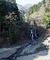 The upstream part of Yōrō Falls, Taki Valley and the trail for Mount Yōrō
 -


See also[edit]
- Japan’s Top 100 Waterfalls
- Mount Yōrō
- Yōrō Station
- Ibi-Sekigahara-Yōrō Quasi-National Park
- Tōkai Nature Trail
References[edit]
- ^ The Mountains around Nagoya. YAMA-KEI Publishers. 2010. ISBN 978-4-635-18017-7.
- ^ Mountain and plateau map, Gozaisyo Ryōzen and Ibuki (山と高原地図). Shobunsha Publications. 2010. ISBN 978-4-398-75724-1.
- ^ "Quasi-National Park". Ministry of the Environment (Japan). Retrieved December 4, 2010.
- ^ The Mountains of Gifu prefecture. YAMA-KEI Publishers. 2009. ISBN 978-4-635-02370-2.