Rural Municipality of Pense No. 160
 From Wikipedia the free encyclopedia
Pense No. 160 | |
|---|---|
| Rural Municipality of Pense No. 160 | |
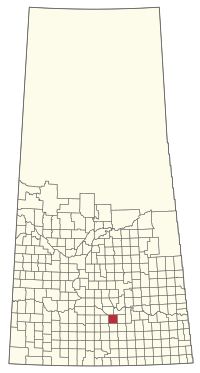
 Location of the RM of Pense No. 160 in Saskatchewan | |
| Coordinates: 50°29′35″N 105°08′42″W / 50.493°N 105.145°W[1] | |
| Country | Canada |
| Province | Saskatchewan |
| Census division | 6 |
| SARM division | 2 |
| Formed[2] | January 1, 1913 |
| Government | |
| • Reeve | Tom Lemon |
| • Governing body | RM of Pense No. 160 Council |
| • Administrator | Cathy Ripplinger |
| • Office location | Pense |
| Area (2016)[4] | |
| • Land | 841.48 km2 (324.90 sq mi) |
| Population (2016)[4] | |
| • Total | 508 |
| • Density | 0.6/km2 (2/sq mi) |
| Time zone | CST |
| • Summer (DST) | CST |
| Area code(s) | 306 and 639 |
The Rural Municipality of Pense No. 160 (2016 population: 508) is a rural municipality (RM) in the Canadian province of Saskatchewan within Census Division No. 6 and SARM Division No. 2. It is located in the southeast portion of the province.
History
[edit]The RM of Pense No. 160 incorporated as a rural municipality on January 1, 1913.[2] Prior to incorporation, the RM had its beginnings in 1897 with a single township having been formed as a local improvement district (LID).[5] In 1904, small LIDs made way for larger LIDs formed in accordance with the LID Ordinance of 1903.[5] The larger LID No. 160 ultimately preceded the formation of the RM of Pense No. 160.[5] In 1923, the population of the RM of Pense No. 160 had risen 2,227 residents.[6]
Geography
[edit]Nicolle Flats Nature Area (Buffalo Pound Provincial Park) is located in the RM as well.[7] The burrowing owl (athene cunicularia), an endangered animal, makes its home in this area. Bigmouth buffalo (ictiobus cyprinellus) is of special concern in this ecoregion.[8]
Communities and localities
[edit]The following urban municipalities are surrounded by the RM.
The following unincorporated communities are within the RM.
- Localities
- Cottonwood
- Eastview
- Kalium
- Keystown
- Madrid
- Pattee
- Schulerville
- Stelcam
- Stony Beach
- Stony Beach Airport
Demographics
[edit]In the 2021 Census of Population conducted by Statistics Canada, the RM of Pense No. 160 had a population of 441 living in 144 of its 157 total private dwellings, a change of -13.2% from its 2016 population of 508. With a land area of 840.18 km2 (324.40 sq mi), it had a population density of 0.5/km2 (1.4/sq mi) in 2021.[11]
In the 2016 Census of Population, the RM of Pense No. 160 recorded a population of 508 living in 158 of its 189 total private dwellings, a 7.9% change from its 2011 population of 471. With a land area of 841.48 km2 (324.90 sq mi), it had a population density of 0.6/km2 (1.6/sq mi) in 2016.[4]
Government
[edit]The RM of Pense No. 160 is governed by an elected municipal council and an appointed administrator that meets on the second Wednesday of every month.[3] The reeve of the RM is Tom Lemon while its administrator is Cathy Ripplinger.[3] The RM's office is located in Pense.[3]
Infrastructure
[edit]Within this RM are 600 km (370 mi) of roads of which the Highway 1 (the Trans-Canada Highway) is one of the main roads.
Education
[edit]This rural municipality was home to several one room school districts such as Leamington, Rose Park, Eastview, Fairville, Coulee, Stony Beach, Rocky Lake, Sarawak, Bruceville, Wayside, Kenilworth, Cottonwood, Wellington, Broadway, Coventry, Blink Bonny, Wascana and Fosest.[12] These have been replaced by consolidated schools and the larger school divisions of today.
References
[edit]- ^ "Pre-packaged CSV files - CGN, Canada/Province/Territory (cgn_sk_csv_eng.zip)". Government of Canada. July 24, 2019. Retrieved May 23, 2020.
- ^ a b "Rural Municipality Incorporations (Alphabetical)". Saskatchewan Ministry of Municipal Affairs. Archived from the original on April 21, 2011. Retrieved May 9, 2020.
- ^ a b c d "Municipality Details: RM of Pense No. 160". Government of Saskatchewan. Retrieved May 21, 2020.
- ^ a b c "Population and dwelling counts, for Canada, provinces and territories, and census subdivisions (municipalities), 2016 and 2011 censuses – 100% data (Saskatchewan)". Statistics Canada. February 8, 2017. Retrieved May 1, 2020.
- ^ a b c "Pense No. 160". Government of Saskatchewan: Sask Biz. 2004. Retrieved December 27, 2007.
- ^ "Municipality of Pense". Rural Municipality Of Pense No. 160. Archived from the original on April 24, 2005. Retrieved December 29, 2007.
- ^ "Pense No. 160", Sask biz, Government of Saskatchewan, retrieved December 29, 2007
- ^ "Saskatchewan Conservation Data Centre - Conservation Database". Saskatchewan Conservation Data Centre. 2007. Retrieved December 26, 2007.
- ^ "Saskatchewan Census Population" (PDF). Saskatchewan Bureau of Statistics. Archived from the original (PDF) on September 24, 2015. Retrieved May 9, 2020.
- ^ "Saskatchewan Census Population". Saskatchewan Bureau of Statistics. Retrieved May 9, 2020.
- ^ "Population and dwelling counts: Canada, provinces and territories, census divisions and census subdivisions (municipalities), Saskatchewan". Statistics Canada. February 9, 2022. Retrieved April 13, 2022.
- ^ "Municipality of Pense", Rural Municipality Of Pense No. 160, archived from the original on April 24, 2005, retrieved December 29, 2007

