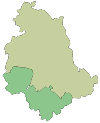
Umbria

Umbria | |
|---|---|
 | |
| Country | Italy |
| Capital | Perugia |
| Government | |
| • President | Catiuscia Marini[1] (PD) |
| Area | |
| • Total | 8,464.33 km2 (3,268.10 sq mi) |
| Population (1 January 2017)[2] | |
| • Total | 888,908 |
| • Density | 110/km2 (270/sq mi) |
| Demonym | umbro |
| Time zone | UTC+1 (CET) |
| • Summer (DST) | UTC+2 (CEST) |
| GDP/ Nominal | €21.8[3] billion (2008) |
| NUTS Region | ITE3 |
| Website | www.regione.umbria.it |
Umbria is one of the twenty regions of Italy, in center Italy. It is the one of the smallest Italian region. Its capital is Perugia.
It is the only region without a coastline or a border with another country.
Geography
[change | change source]The region is located in Central Italy with an area of 8,464.33 km2 (3,268.10 sq mi).[4] It is bordered by Marche to the east and northeast, Tuscany to the west and northwest, and Lazio to the south and southwest.
The main river in the region is the Tiber. Other important rivers are the Nera, Paglia, Topino, Chiascio and Nestore.
The largest lake of Umbria is the Trasimeno, one of the largest lake of Italy.
The highest mountain in the region is Cima del Redentore, in the Sibillini Mountains (Italian: Monti Sibillini), with an altitude of 2,448 m (8,031 ft).
Provinces
[change | change source]Umbria is divided into two provinces:
| Province | Abbreviation | Capital | Area (km²) | Population[2] (1 January 2017) | Density (inh./km²) | Comuni |
|---|---|---|---|---|---|---|
| Perugia | PG | Perugia | 6,337.15 | 662,110 | 104.5 | 59 |
| Terni | TR | Terni | 2,127.18 | 229,071 | 107.7 | 33 |
| Total | 8,464.33 | 888,908 | 105.0 | 92 | ||
Largest municipalities
[change | change source]The 10 comuni with more people living in it are:
| No. | Comuni | Province | Population[2] (2017) | Area[5] (km2) | Density (inh./km2) |
|---|---|---|---|---|---|
| 1 | Perugia | PG | 166,676 | 449.51 | 370.8 |
| 2 | Terni | TR | 111,455 | 212.43 | 524.7 |
| 3 | Foligno | PG | 57,164 | 264.67 | 216.0 |
| 4 | Città di Castello | PG | 39,740 | 387.32 | 102.6 |
| 5 | Spoleto | PG | 38,035 | 348.14 | 109.3 |
| 6 | Gubbio | PG | 31,939 | 525.78 | 60.7 |
| 7 | Assisi | PG | 28,379 | 187.19 | 151.6 |
| 8 | Bastia Umbra | PG | 21,784 | 27.60 | 789.3 |
| 9 | Corciano | PG | 54,311 | 63.72 | 852.3 |
| 10 | Orvieto | TR | 21,349 | 281.27 | 75.9 |
References
[change | change source]- ↑ "La Presidenta" (in Italian). Regione Umbria. Retrieved 18 July 2016.
- ↑ 2.0 2.1 2.2 "Statistiche demografiche ISTAT" (in Italian). Demo.istat.it. Archived from the original on 3 January 2018. Retrieved 3 October 2017.
- ↑ "Eurostat - Tables, Graphs and Maps Interface (TGM) table". ec.europa.eu.
- ↑ "Umbria" (in Italian). Tuttitalia.it. Retrieved 18 July 2016.
- ↑ "Comuni umbri per popolazione" (in Italian). Tuttitalia.it. Retrieved 3 October 2017.
Other websites
[change | change source]- Official Site Archived 2011-02-11 at the Wayback Machine (in Italian)


