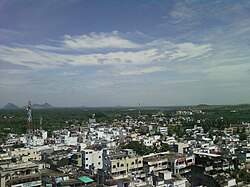
Tagarapuvalasa

Tagarapuvalasa | |
|---|---|
 View of Thagarapuvalasa Town | |
| Coordinates: 17°55′52″N 83°25′44″E / 17.93111°N 83.42889°E | |
| Country | |
| State | Andhra Pradesh |
| District | Visakhapatnam |
| Mandal | Bheemunipatnam |
| Government | |
| • Type | Municipal Corporation |
| • Body | GVMC |
| Telugu Languages | |
| • Official | Telugu |
| Time zone | UTC+5:30 (IST) |
| PIN | 531162 |
| Telephone code | +91-8933-XXX XXX |
| Vehicle registration | AP-31 |
Tagarapuvalasa is a neighbourhood on the banks of River Gosthani is a part of Bheemunipatnam Municipality (BMC) in Andhra Pradesh.[1] It is located on the Kolkata–Chennai National Highway 16.
National Highway 43 diverts from Maharajupeta village north of Tagarapuvalasa. [citation needed]
History
[edit]Traces of habitation and early trade in and around Tagarapuvalasa may be dated back to 3rd century BC or more as many Early Buddhist sites such as Pavurallakonda, Gudiwada Dibba,[2] Cherukupalli Gutta[3] and Pellikonda,[4] are explored, documented and excavated near to this town along the River Gosthani. This area once flourished as Madhyama Kalinga region.
Geography
[edit]Tagarapuvalasa and Chittivalasa are twin towns and located at 17°55′52″N 83°25′44″E.[5]
Transport
[edit]- APSRTC routes
| Route Number | Start | End | Via |
|---|---|---|---|
| 222 | Tagarapuvalasa/Chittivalasa Jn. | Railway Station/RTC Complex | Anandapuram, Madhurawada, Yendada, Hanumanthuwaka, Maddilapalem |
| 222V | Vizianagaram | RTC Complex | Tagarapuvalasa/Chittivalasa Jn., Anandapuram, Madhurawada, Yendada, Hanumanthuwaka, Maddilapalem |
| 111 | Tagarapuvalasa/Chittivalasa Jn. | Kurmannapalem | Anandapuram, Madhurawada, Yendada, Hanumanthuwaka, Maddilapalem, RTC Complex, Jagadamba Centre, Town Kotharoad, Convent, Scindia, Malkapuram, Gajuwaka |
| 111V | Vizianagaram | Kurmannapalem | Tagarapuvalasa/Chittivalasa Jn., Anandapuram, Madhurawada, Yendada, Hanumanthuwaka, Maddilapalem, RTC Complex, Jagadamba Centre, Town Kotharoad, Convent, Scindia, Malkapuram, Gajuwaka |
| 211 | Vizianagaram | Visakhapatnam Railway Station | Tagarapuvalasa/Chittivalasa Jn., Anandapuram, Madhurawada, Yendada, Hanumanthuwaka, Maddilapalem, RTC Complex |
| 900T | Tagarapuvalasa/Chittivalasa | RTC Complex | Bhimili, Thimmapuram, Rushikonda, Appughar, Pedawaltair, Siripuram, RTC Complex |
| 888 | Tagarapuvalasa/Chittivalasa Jn. | Anakapalli | Anandapuram, Gudilova, Shontyam, Pendurthi, Sabbavaram, Sankaram |
| 55T | Tagarapuvalasa/Chittivalasa Jn. | Scindia | Anandapuram, Gudilova, Shontyam, Pendurthi, Vepagunta, Gopalapatnam, NAD Kotharoad, Airport, BHPV, Gajuwaka, Malkapuram |
References
[edit]- ^ "Mandal wise list of villages in Andhra Pradesh" (PDF). Apland.ap.nic.in. Archived from the original (PDF) on 19 March 2015. Retrieved 7 September 2013.
- ^ B. Madhu Gopal (9 October 2012). "Evidence of Buddhist site found". The Hindu. Retrieved 7 September 2013.
- ^ "Buddhist remains site at kotta cherukupalli (Tagarapuvalasa) | interesting place". Wikimapia.org. Retrieved 7 September 2013.
- ^ "Pellikonda Buddhist Site | place with historical importance, archaeological site, interesting place". Wikimapia.org. Retrieved 7 September 2013.
- ^ "Maps, Weather, Videos, and Airports for Chittivalasa, India". Fallingrain.com. Retrieved 7 September 2013.
